This section covers the Sugarland Run greenway from the W&OD Trail in Herndon to Leesburg Pike. The entire stream valley extends about 10 miles between Spring Street in Herndon and the Potomac River.
Maps of Sugarland Run in pdf format suitable for printing may be accessed by clicking here. You will need Adobe Reader to view and print the maps.
There are only 2 pedestrian only bridges across the stream north of Elden Street in the greenway and both are in the town of Herndon. There are no pedestrian bridges in the Fairfax County section of the trail. There is a sidewalk along the Wiehle Avenue bridge that crosses the stream. These bridges may be the only means of crossing the stream under high water conditions other than at the end points on this map.
There are 2 parks in this section of the valley, Runnymede Park which is run by the town of Herndon and the Sugarland Run Stream Valley Park which is run by the Fairfax County Park Authority. The 2 parks meet at the Herndon town line.
There are only 2 rock stream crossings of Sugarland Run in Runnymede Park. The rock crossing near Hunter's Creek Clubhouse used to be a bridge until it washed out. The only Runnymede Park trail on the eastern side of Sugarland Run is a portion of the Sycamore Trail which utilizes both rock crossings.
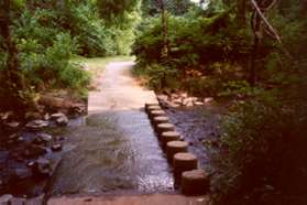
All of the stream crossings in the county park are on columns. The columns have been placed on concrete ramps across the stream. Some of the ramps are steep and can get muddy. Care should be taken under muddy conditions to avoid sliding into the stream. The stream is only a few inches deep at the ramp crossings under normal conditions.
|
|
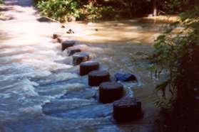
The picture on the left shows the columns across the stream under normal conditions. The picture on the right shows the columns one day after a heavy rain. This could also happen after a downpour. Past and future weather should always be considered before planning to cross Sugarland Run on the columns or the rocks.
 |
|
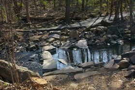
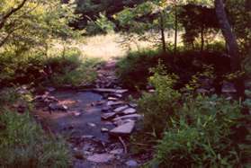
The picture on the above left shows a typical small rock crossing. Small rock crossings are more difficult to maneuver than column crossings and can also be a problem under high water conditions. Small rocks also may wash away during heavy stream flows. The picture on the above right is a large rock crossing. These can be easier to cross than column crossings because there is more surface to step on. Large rocks are not easily moved after heavy rains.
Most of the park is wooded and in shade. A number of people were met walking or jogging in the park. Many of the neighboring streets offer a loop return path via the extensive sidewalk system which is shown on the map. Every street on the west side of Sugarland Run has a sidewalk making walking a pleasure.
Custom maps are provided for suggested walks in the Sugarland Run Valley. If you are new to this area take the Introduction Walk first to get acquainted with the stream crossings. Here is a listing of the current walks along Sugarland Run on this site: