Sugarland Run - Runnymede Park
Walk Route Prior To December 2005
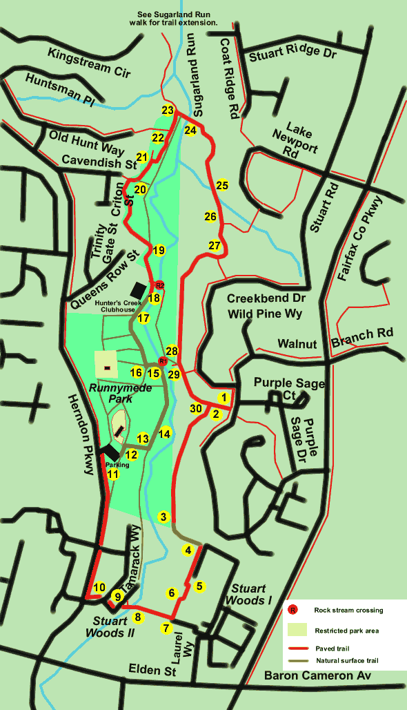
Runnymede Park
Length:
2.4 miles
Surface:
paved and natural surface trails
Exposure:
sun and shade
Surroundings:
woods, stream, homes
Directions:
This is one of a series of walks in the Sugarland Run area. Sugarland Run closely
follows the border between Reston and Herndon. Wiehle Avenue is the only road
crossing between Elden Street and Leesburg Pike but there are many stream crossings
for walkers. This joins the neighborhoods on both sides of the stream and there
are many similarities in the system of paths and other amenities on both sides.
This loop walk will take you through Runnymede Park in Herndon but starts in
Reston.
This walk crosses Sugarland Run and another stream on concrete columns. The
columns are placed on a concrete ramp that crosses the stream underwater. Mud
on the sloping ramp can be very slippery after it rains so be careful when approaching
the columns. After a heavy downpour the stream can get quite high and flow over
the tops of the columns. Normally, the stream is only a few inches deep at the
crossings. Click on points 24 and 25 on the map to view pictures of the crossings.
- The walk starts in Reston opposite Purple Sage Court on Walnut Branch Road.
There is parking along the street at this location. Take the path away from
Purple Sage Court going west. Note the utility box along the path in the picture.
- Turn left at the first asphalt trail. The trail quickly heads into the trees
and houses will be seen on the left.
- There is a Trail Ends sign at the end of the paved portion of the path.
Continue following the natural surface trail. There is a tree down across
the dirt path but it is possible to climb over it. Do not take side paths
to the houses on the left but stay on the path to the right until reaching
the Stuart Woods Apartments. The town of Herndon may be placing an asphalt
trail in this section in the future.
- The trail leads to the side of the Stuart Woods Apartments. Go to the parking
area and turn right to follow the sidewalk in front of the buildings.
- At the end of the parking area the sidewalk leads into an asphalt trail
along the side of tennis courts.
- The buildings start back up on the other side of the tennis courts. Follow
the concrete sidewalk in front of the buildings.
- At the intersection with a sidewalk to the right turn right and follow the
sidewalk. It quickly turns into an asphalt path.
- The asphalt path crosses Sugarland Run on a bridge. Turn left at the trail
intersection and continue to the parking area.
- Cross the parking area and take the sidewalk along the entrance road on
the other side.
- Cross Tamarack Way and take the trail on the other side with Tamarack Way
on the left.
- Turn right and follow the sidewalk along Herndon Parkway. Herndon Parkway
will be on the left.
- Turn right at the driveway leading into Runnymede Park. Walk back through
the parking area to the kiosk shown in the picture. Walk across the grassy
area from the kiosk to the Woodland Path which starts at the woods in back
of the house. The houses in the park are occupied and are off limits to visitors.
There is a sign marking the path as shown in the picture.
- The Woodland Path goes only a short distance through the woods when it
intersects with Sycamore Trail at a clearing. Turn left to follow that trail.
It is also marked with a sign.
- The short section of gravel will help to confirm that you are on the right
trail.
- Continue on the Sycamore Trail until you come to a stream crossing. Turn
left immediately before the stream crossing. The trail is labeled Mill Race
Path and it has boards. Before turning left onto the path you may wish to
look to the right at the new beaver pond. Beavers were wiped out along here
when an oil pipeline burst near Reston Hospital and overflowed into this stream.
- Turn right onto the marked Redbud Path at the first trail intersection.
Continue on Redbud Path past several trail intersections.
- Redbud Path leaves the woods near the Hunters Creek Clubhouse. Continue
straight towards the right of the building.
- A paved trail (marked as the Hunters Creek Trail) starts at the clubhouse.
Follow it and pass the swimming pool on your left. Just past the swimming
pool is an asphalt trail to the right leading to another stream crossing where
the bridge was washed out. Continue on the present trail. (The bridge used
to carry the Sycamore Trail back across the creek to the clubhouse.) After
a short distance the Hunters Creek Trail crosses a bridge.
- The asphalt trail turns left at the intersection with a natural surface
trail (Redwing Trail) which is partially blocked by a gate. Continue on the
asphalt trail.
- An asphalt trail intersects from the left. Continue on the present trail
to the right. Just beyond this a natural surface trail leads to the right
to a gate. Stay on the asphalt trail to the left. The natural surface trail
is marked as the Cavendish Spur.
- An asphalt trail leads to the left. It is a dead end so stay to the right.
- An asphalt trail leads to the left. It is marked as Old Hunt. Continue
on the present trail. This is the last trail intersection in Runnymede Park.
- Turn right at the next asphalt trail connection. You are now in Fairfax
County.
- The path crosses Sugarland Run on columns. You are now back in Reston. Continue
on the asphalt path.
- The path crosses a smaller stream on columns. Continue on the asphalt path.
- An asphalt trail intersects from the left. Continue on the present path.
- An asphalt trail intersects from the left. Continue on the present path.
On your next walk along this route you might turn left at this point and take
this trail to Creekbend Drive. Turn right at the sidewalk there and follow
it back to the starting point on Walnut Branch Rd. This will give you the
chance to view the fronts of some of the homes in the area.
- The short section of asphalt to the right also is the starting point for
a natural surface trail that connects to the rock crossing where you turned
on the other side of Sugarland Run (point 15 on the map). You might take a
short detour to view the crossing from the other side. After the detour continue
straight on the present trail.
- An asphalt trail intersects from the left. Continue straight on the present
trail.
- An asphalt trail intersects from the right. Continue straight on the present
trail. The intersection with the road just ahead marks the return to the starting
point for this walk.
Next
- Pictorial Directions
Home
- Contents - Links