Riverbend Park to Great Falls
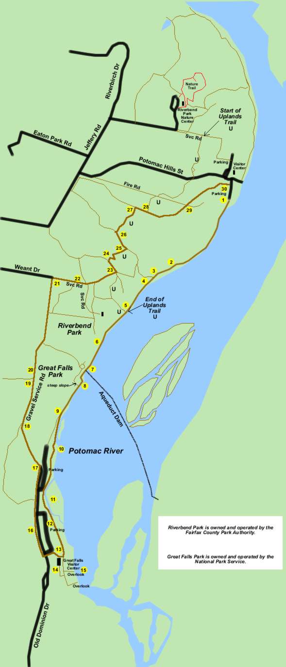
Riverbend Park to Great Falls
Length: 3.8 miles (to visitor center)
Surface: natural surface trails and gravel service roads
Exposure: mostly shade
Surroundings: woods and river
Directions:
This walk starts at the Riverbend Park visitor center and follows the Potomac River to the Great Falls Park visitor center. Should you miss the turn for the Riverbend Park visitor center while driving you will end up at the nature center.
The walk utilizes natural surface trails that can become quite muddy after rainfall. This is particularly true along the Potomac River. Allow several days of dry weather if you wish to avoid the mud.
The return loop utilizes several service roads and a series of wooded trails. It makes a number of turns in the final portion of the walk. Keep track of your location on the map so that you know which turn to take, as there are few landmarks in the woods.
- The trail starts at the southern end of the parking lot near the Riverbend Park visitor center. Note that there is also a parking lot adjacent to the visitor center. (The visitor center is on the river while the nature center is not.) Take the natural surface trail south along the river in a downstream direction.
- Notice the lean on the large old trees in the picture. One wonders how the root structure can keep them from tipping over.
- The trail enters a cleared area. The display board in the picture sits next to a trail to Weant Drive. Continue on the trail along the river.
- The sign in the picture provides assurance that this is the path to Great Falls. The picture was taken in April. Place your mouse over the picture to view the path in August. The brush grows well here because of the fertile soil provided by the river during floods.
- The sign in the picture marks the Uplands Trail. Continue on the present trail along the river.
- This small bridge marks the park boundary. Look behind you to see the sign for Riverbend Park.
- The sign in the picture marks the start of Great Falls Park. The path crosses a rocky ledge here. To the left is the aqueduct dam that feeds the water supply to Washington.
- The path follows a service road.
- Look for a path on the left leading to a large sign warning of the water hazards. Place your mouse over the picture to view the sign more clearly as well as the path. Leave the service road and follow the path along the river.
- This vehicle barrier will provide assurance that you are on the correct path.
- The Patowmack Canal appears on the left.
- The massive stones along the canal are the upper guard gate walls.
- The trail reaches the visitor center.
- The entrance to the visitor center is on a ramp on the opposite side of the building. There are interesting exhibits inside.
- This is a view of the falls from an overlook. There are 2 formal overlooks.
- To return to Riverbend Park walk across the parking lot to the west side where there is a path along the road. Walk north along the path so that the parking lot is on your right.
- The first parking lot will end. Continue on the path and a second parking lot will appear. Continue to a service road that goes up the hill to the left. The road surface quickly changes from asphalt to gravel. Take the service road up the hill away from the parking area.
- A trail marker appears beside a path to the left. Continue up the hill on the service road.
- Another trail marker appears on the left. This trail connects to River Bend Road. Continue on the present service road. Ignore the trails leading to the right off the service road.
- A fence appears on the left marking the start of private property. The homes that soon appear are accessed from other roads.
- A barrier appears at the end of the service road marking the start of Weant Drive. Turn right onto the service road leading away from Weant Drive.
- The service road turns right at a barricade across an intersecting trail. Leave the service road taking the trail with the barricade across it.
- A yield sign and a column sign mark the crossing of the Uplands Trail. Turn left to follow the Uplands Trail. The trail climbs a slight hill.
- Turn right at the next trail intersection to continue following the Uplands Trail. A column sign marks the trail. The trail descends a hill.
- Turn left at the next trail intersection to continue following the Uplands Trail. A column sign marks the trail. The trail follows a creek on the right.
- Turn right at the next trail intersection to continue following the Uplands Trail. A column sign marks the trail. The trail crosses the creek on a bridge and goes up a hill.
- Turn right at the next trail intersection to continue following the Uplands Trail. A column sign marks the trail.
- After a short distance a column sign indicates that the Uplands Trail turns left. You will be leaving the Uplands Trail at this point. Continue straight on the present trail.
- The trail turns slightly left and shortly intersects with another trail. Continue straight on the present trail. Shortly it will start down a steep hill.
- The trail reaches the parking lot at the starting point. The river is once again visible.