Lake Fairfax Park From W&OD Trail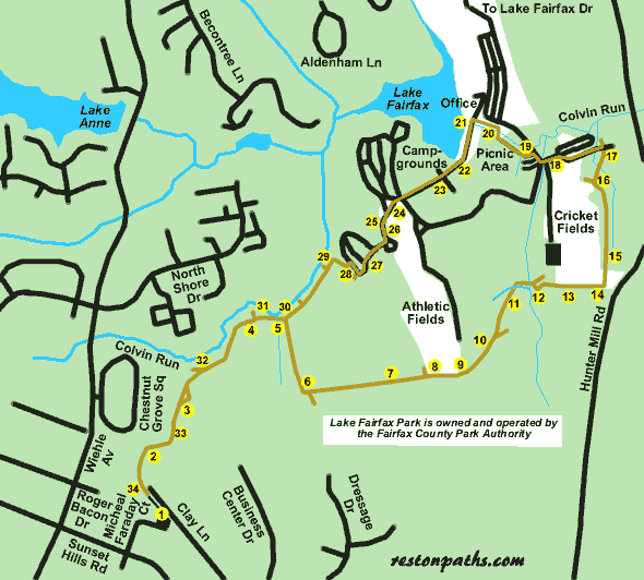
Lake Fairfax Park From W&OD Trail
Length: 4.0 miles
Surface: natural surface
Exposure: shade and sun
Surroundings: woods, park, lake
Directions:
This walk will take you entirely within Lake Fairfax Park once you leave the parking lot at the starting point. Most of the route is a mountain bike trail that continues into the Difficult Run watershed. Weekdays are the best time to hike this route as a considerable number of bikers use the route on weekends and holidays.
This is a natural surface trail and it can get quite muddy during wet periods. Also, there are 4 stream crossings to be made without benefit of a bridge. The stream crossings can be viewed by clicking on points 5, 11, 12, and 30 on the map.
If you enjoy this walk you may also enjoy the Buttermilk Creek Trail which also offers a view of Lake Fairfax.
- The starting point is at a parking lot at the end of Michael Faraday Court. Turn right into the driveway at the end of the street. A parking lot will appear on your left. Turn left and park at the rear of the parking lot. Follow the pavement along the northwest portion of the parking lot to the trail leading into the woods. After stepping off the pavement onto the dirt path you have entered Lake Fairfax Park and left Reston. The trail will go down the hill at that point.
- The trail curves to the right and levels off. It then starts down hill again curving to the left.
- The trail splits. Take the upper portion of the trail to stay out of the mud. Both portions rejoin.
- The trail to the left goes to North Shore Drive. Take the trail to the right.
- This is the first stream crossing. Try to find rocks to aid you in crossing. The return path will approach from the left. Take the path to the right up the hill.
- Near the top of the hill the path turns to the left. The photo shows a path almost hidden on the right that connects to Dressage Drive. Continue on the present path as it follows along the park boundary. You may notice remains of a barbed wire fence on your right.
- The path goes down hill. Along the way you will find logs placed across the path as shown.
- The trail climbs a hill. At the top a path branches off to the left. This path goes to the campgrounds. Just beyond this are the athletic fields. The mountain bike trail goes to the right as indicated by the horseshoe sign. The path follows a fence marking the park boundary.
- The path enters the woods again on the other side of the athletic field. It then curves to the left.
- At the next path intersection continue on the present trail to the left.
- The path goes down a steep hill and crosses a small creek. It then follows the creek on the other side.
- The path crosses a wider creek. Take the narrower trail to the right on the other side. The path goes up a hill and turns sharply left as shown.
- The path continues up the hill and emerges along another boundary fence.
- Follow the fence through the grassy field until coming to a marker shown prior to Hunter Mill Road (the road visible in front of you). Turn left across the field walking parallel to Hunter Mill Road but at some distance from it.
- Follow the gravel road from the edge of the field following the horseshoe markers. The gravel road is roughly parallel to Hunter Mill Road.
- The gravel road turns slightly to the left where a path diverges to the left. Continue on the gravel road as it turns to the right and goes down a hill.
- At the bottom of the hill take the intersecting road to the left. The road goes through a picnic area.
- At the stop sign turn right and follow the paved road to the gravel road on the left just prior to the creek crossing.
- Turn left on the gravel road. It serves as parking for a picnic area and ends at a pedestrian bridge.
- After the bridge continue on the gravel trail turning right onto the trail across another bridge. After crossing that bridge turn left. Walk across the grass and up the hill roughly parallel to the stream until you meet a paved trail at the top of the hill.
- Turn left onto the paved trail and walk across the dam.
- At the other end of the dam the trail goes up a hill.
- At the top of the first hill continue past the chain across the trail and follow the trail (which now becomes a road) up the next hill.
- At the top of the hill the athletic fields appear on the left and a RV area on the right. Follow the road as it crosses the field and turns to the left. Follow the signs for Campground C.
- The road enters the trees paralleling the athletic field.
- The road turns right. There is a turnaround to the left. Follow the road to the right down the hill.
- At the next road intersection stay to the left. Another road appears to the right but continue on the present road to the left. The road turns as a small pedestrian bridge appears. Follow the road to the right.
- After a short distance take the trail to the left marked Nature Trail. The trail crosses a small gully on a bridge and turns right into the woods.
- The trail turns to the left and a marker appears at a side trail. Continue straight on the present trail past this and the next side trail.
- At the next trail intersection take the trail to the right. This is the trail that originally brought you here. Cross the creek on the right as you did previously.
- At the next trail intersection keep to the left. The trail to the right goes to North Shore Drive.
- At the next trail intersection keep to the left. The trail to the right goes to Wiehle Avenue.
- After climbing a hill a building will appear on the left. This is the back of the National Wildlife Federation and you are close to the starting point of the walk.
- The path rejoins the parking lot where you started the walk.