Great Falls MD - Anglers Inn to Great Falls Tavern
Great Falls
MD - Anglers Inn to Great Falls Tavern
Click here
for trail map and directions in pdf format for printing.
You will need
Adobe Reader to print the information in pdf format. Click here
to proceed to the Contents page for a link to this free software.
For
information on Virginia side of Great Falls click here.
Length:
4.6 miles
Surface:
natural surface
Exposure:
mostly sun
Surroundings:
canal, river, woods, falls
Directions:
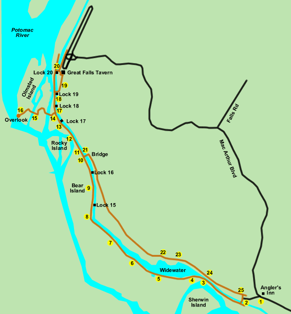
This walk offers excellent views of the Potomac River and Great Falls as well
as some history of the C & O Canal. The parking lot across from the Anglers
Inn fills up quite early (before 9:00 AM) on weekends and holidays so the route
is best walked on weekdays when there is usually plenty of space. The walk can
also be started from the Great Falls Tavern where there are many more parking
spaces but also a service charge.
The towpath is in good shape over the entire the route. Previously flooding
had removed the smooth surface between Widewater and Lock 15. The pictures at
locations 7 and 8 on the map will give you some idea of the rocky surface prior
to 2006 in that area plus a view of the current conditions.. Bicyclists no longer
have to take a detour around that section.
The overlook is wheelchair accessible from the Great Falls Tavern parking lot.
- The parking lot is located at the point where MacArthur Blvd. leaves the
canal and heads north up the hill. Turn left with the Anglers Inn sign on
your right to enter the dirt road leading to parking. There are several parking
areas along the dirt road. After parking walk to the end of the dirt road.
- At the end of the parking area take the trail to the left towards the canal.
Cross the canal on the bridge shown and turn right to walk on the towpath
with the canal on your right. The river can be seen below through the trees.
- The river separates from the canal at this point.
- The canal widens. This section is know as Widewater and was taken from a
channel that used to carry a branch of the river. This saved several miles
of blasting. A sign on the left marks one end of the first section of the
Billy Goat Trail.
- A bridge crosses an outlet from the canal. You will note a mechanism on
the left to control water flow from the outlet.
- Widewater starts to narrow at this point and the towpath climbs a small
rise.
- The towpath turns rocky here. Repeated flooding washed out the clay towpath
here and it was decided not to make repairs since they would only be washed
out in the next flood. The area is walkable with care but bicyclists will
have to carry their bikes here.
- The damaged area of the towpath has been repaired. The pictures will show
you both the former and the current condition. Lock 15 was the end of the
formerly damaged section.
- This is Lock 16. The Locktender lived in the house.
- A bridge crosses over the towpath and the canal. You will use this bridge
on your return to the parking area near Anglers Inn.
- This is the other end of the first section of the Billy Goat Trail.
- An excellent view of the river is offered from this location. You may be
able to see kayaks being ridden in this section.
- This is a view of Lock 17. The trail to the overlook is just beyond this
point.
- Turn left at the sign marking the trail to the overlook. A bridge can be
seen crossing the first passage of the river. A view of the river is shown
from the bridge.
- This is the bridge over the second river passage. A view of the river here
is also provided.
- This is the overlook to Great Falls. The view of the overlook from the Virginia
side of the river will give you some idea of the composition of the island
that you are on. You may be able to see a blue heron below the overlook. A
panoramic view of the falls is shown.
- Retrace your steps on the overlook trail. Upon reaching the towpath turn
left to take a relatively short walk to the Great Falls Tavern. Lock 18 can
be seen in the picture.
- After passing Lock 19 turn right to cross the canal on a bridge.
- These are views of the tavern. There is a museum inside the building. Restrooms
are located behind the building towards the parking area.
- To make the return trip cross the canal at the bridge in front of the tavern
building. Turn left along the towpath so that the canal is on your left.
- Stay on the towpath. You will pass the trail to the overlook on your right.
A bridge will pass over the towpath and the canal. Walk up the steps and take
the bridge to the other side of the canal. Turn right and follow the dirt
road. Stay on this road until step 25. The road will separate from the canal
for a distance but will later rejoin the canal. This road used to serve as
a detour for bicyclists around the rocky section of the towpath and connects
to the parking area near Anglers Inn. Pipes under this road supply water to
Washington.
- The road overlooks the Widewater section of the canal.
- This tree along the road appears to be growing out of solid rock.
- The road gets very close to the canal and a railing appears on the side.
- Several signs with arrows mark a trail to the right. Take the steps down
the hill and turn left to return to the parking area.